
The Dales Way – Great Yorkshire Walks
How to get to The Dales Way

Officially, the Dales Way starts at Ilkley, although other offshoots to Leeds, Bradford and Harrogate have been developed over time. This is one of the most spectacular walks in the county, taking in some of highest hills in the Dales. Walkers can wander through the Bolton Abbey Estate, take in the glories of Wensleydale and end up looking at some of the highest points in Yorkshire, including the three peaks, Pen-y-Ghent, Whernside and Ingleborough. Further along the trail takes you into the Lake District, ending on the shores of Lake Windermere.
The Dales Way Links
Firstly, three offshoots exist linking other public footpaths to the Dales Way from three major cities and towns.
From Leeds
The link to the Dales Way, heading to its official starting point in Ilkley is just north of the A6120 ring road at Adel. The Meanwood Valley Trail merges with the Dales Way path, which takes you eventually to Ilkley. On this link walkers are taken through Bramhope, the Otley Chevin, Menston, Ilkley Moor and to the town centre to the official starting point of the Dales Way near the Riverside Gardens.
From Bradford
The Bradford link starts at the cathedral and takes you through the Northern suburbs of the city, such as Shipley, Saltaire and Baildon to the southern edge of Ilkley Moor. The link cuts straight across this moorland into the town centre and the starting point of the Dales Way.
From Harrogate
Approaching the Dales Way from the east, this link starts at the Royal Pump Museum near Crescent Road in Harrogate town centre. The route goes through both the Valley and Harlow Carr Gardens into the countryside. The link winds its way past Fewston and Swinsty reservoirs and enters Ilkley from the north to the official starting point of the Dales Way.
The Official Dales Way Route
Stage 1 – Ilkley to Burnsall (15 miles)
The starting point for the Dales Way lies on the banks of the River Wharfe on Bridge Lane, near the Riverside gardens. The path then leads walkers out of Ilkley towards Addingham, following the course of the river. This former textile village still has many structures from its 19th Century heyday. It has 100 listed buildings, which is unusual for a village of its size.
Still hugging the course of the river Wharfe, the path proceeds northwards onto the Bolton Abbey estate. Owned by the Duke and Duchess of Devonshire, this area was the site of Bolton Priory, which until its destruction in 1539, as part of the Dissolution of monasteries. Until then it was an important religious and educational centre. The priory ruins stand alongside the fully functional St Mary’s and Cuthbert parish church on the banks of the Wharfe. The fun part in this stage of the walk is navigating the 57 stepping stones across the river, although a bridge is also provided if you don’t want to risk getting your feet wet.

The path proceeds through the heart of the Bolton Abbey Estate, past the Riverside cafe, if you fancy a stop off, and onwards to the beautiful Strid Woods.
This is an area of special scientific interest because as the river narrows the rocks soften causing the water to flow fast through them, creating waterfalls. The area also has the largest amount of acidic oak trees in Yorkshire and is home to a wide range of birdlife, such as Wood Warblers, Nuthatches, Dippers and Goosander to name but a few.
As you leave the Bolton Abbey estate to the North look out for Barden tower, which is the ruins of an old hunting lodge, dating back to the 15th Century. The footpath continues north for several miles, crossing the river at intervals over bridges.
Eventually you arrive at the picturesque village of Burnsall and it is well worth stopping awhile to take in the scenery before you and perhaps stop at one of the inns.
Stage 2- Burnsall to Buckden (15 miles)

Dragging yourself away from Burnsall is not easy, but there is so much more lying in store further up the route.
After continuing along the river for a few miles it may be worth stopping to look at Linton falls. These were created when a shift in the earth’s crust caused the rocks to the north to rise above those to the south, causing water to rush down them. The force of this water has meant that a small hydroelectric plant was re-opened in 2012, after lying derelict for sixty years to supply electricity to nearby homes.
Soon the Dales Way snakes through the cobbled streets of Grassington. This area is rich in ancient history and archaeological digs here have discovered the remains of two nearby villages possibly dating back to around 2000BC. Grassington was a lead-mining and quarrying town, which nowadays lends itself to tourism.
Proceeding on, the path takes you northwards through quite a desolate, but equally tranquil part of the walk between Grassington and Kettlewell. The geography in these parts is very interesting and the limestone pavement throws up an interesting mix of hills and sinkholes, carved out through the erosion of the limestone rock and boulder clay by acid rain. These can be 2-3 metres deep and pock-mark the countryside as you walk.
This part of the 5 mile walk between Grassington and Kettlewell cuts through the Yorkshire Wildlife Trust owned, Grass Wood Nature reserve, which is an ideal place to see Green Woodpecker, Woodcock and during the summer, Pied Flycatchers and Willow Warblers.
Kettlewell is another village firmly marked on the Dales tourist’s map. This has a range of inns and shops to stop and replenish yourself after that long walk through the limestone.
Across the hills you may be able to make out the village of Arncliffe, which is where the original Emmerdale Farm was filmed in the early 70s.
By now the River Wharfe will be looking a shadow of its former self, as you climb higher into the Yorkshire Dales National Park. Soon you will come across the village of Starbotton. The remains of a smelting mill can still be seen here on the hillside, which was operational until 1862.
Carrying on up the path you reach the village of Buckden. This sits under the impressive Buckden pike, which stands 702m (2303ft) high. There is also a disused lead mine here, which closed in 1877. The Dalesbus also operates from the village, so a route back to Ilkley or other Dales towns can be achieved by public transport if required.
Stage 3 Buckden – Low Gearstones 12 miles

Leaving Buckden on the path takes you deeper into the dales and towards some of the highest peaks in the county. A few miles down are the very secluded villages of Hubberholme and Yockenthwaite. If you are in need of refreshment the George Inn at Hubberholme is the last pub you will see on the Dales Way until it heads into Cumbria. Each year, in the first week of January a “parliament” led by the local vicar is held in this pub to auction the grazing rights to the pastures for the following year. The proceeds of the auction are used towards helping the elderly in this remote parish.

The River Wharfe, you have loyally followed all the way from Ilkley resembles nothing more than a beck. The meadows around this tiny village are areas of Special Scientific interest and rare plants, such as common knapweed, bird’s foot trefoil and three species of orchid grow here.
As you head towards Oughtershaw, the scenery is dotted with caves and becks. One of these, Greenfield Beck merges with Oughtershaw Beck near the hamlet of Beckermonds to form the source of the River Wharfe.

Several miles of stunning countryside follows, including an old Roman road to look out for near Far Gearstones. Near here is Cam end, which at 1710ft above sea level is the highest point in the Dales Way.
Stage 4 Low Gearstones to Sedbergh (15 miles)
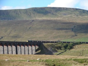
To the west of Gearstones is one of the three peaks, Whernside, which at 735m above sea level is one of the highest peaks in Yorkshire. In walking up to Cowgill, you have just crossed the Yorkshire/Cumbrian border. Although you are now in foreign territory, this county carries on where Yorkshire left off and the hills get higher and higher through Dentdale to the village of Dent. This charming cobbled village is well worth a look around, particularly its church dedicated to St Andrew.
Hugging the River Dee the footpath takes you up to the sizable town of Sedburgh, which offers a range of shops and inns to choose from if required and public transport.
The rest of the way…
The all-Cumbrian stretch of the Dales Way, from Sedburgh to Bowness on Windermere is about 22 miles. It circumnavigates Kendal, even across the M6 at one stage, and gives stunning views of the Howgill fells near Sedburgh and the Southern Lake District. The end of the walk is at Bowness Bay end of Windermere and marks what has been a truly epic journey from Ilkley, which is 81 miles away to the south.
